All 11 Great Walks of New Zealand, Ranked
- Apr 3
- 18 min read
When I originally began looking into spending time in New Zealand, I knew I wanted to focus on exploring all the natural beauty the country was known for, especially in terms of trails. At the time, I had only heard of the Milford Track, but as I began to do research, I discovered that it was just one of 11 Great Walks New Zealand had to offer. Naturally, I expanded my goal to accomplish all of them. Now that I have done so, I will share my rankings and highlights of each of them.
11. Rakiura Track

Based in Stewart Island, this loop track is the most remote of the Great Walks, starting and ending in the tiny (and only) town of Oban. While I am very glad to have visited the island, south of even the South Island, the walk itself was not spectacular. I added on extra coastal walks to the beginning and end of the walk to try and enjoy the coastline more, which did help. Perhaps due to its remoteness, however, it felt like the Great Walk which got the least amount of attention from the Department of Conservation (DOC).

The first day was definitely the best day, with the most beaches and views. I also got to see wild deer and plenty of ducks at the first hut I stayed at. It is possible to find kiwis along this track, but I had no success on my own. The second day involved backtracking on the trail and then cutting across the island, meaning there were no coastal views. It did not help that it rained that day, and the mud, even while being treated as a sort of puzzle to navigate around, was a lot to deal with.

Unfortunately, this was also an area that used to be logged, so there were less old growth trees than I was hoping. That said, there were still some really cool ones in places. The third day put me back on the coast, but being so far south, I was not tempted to hop in the water.

Despite Rakiura being last on my list, it was still a very worthwhile venture going out to Stewart Island. Most notably, the Kiwi tour I took was absolutely spectacular, and was a major highlight of my whole time in New Zealand. I also got to see penguins and seals on that tour, making it all the more special. Even the wild ferry ride to the island was a remarkable experience.
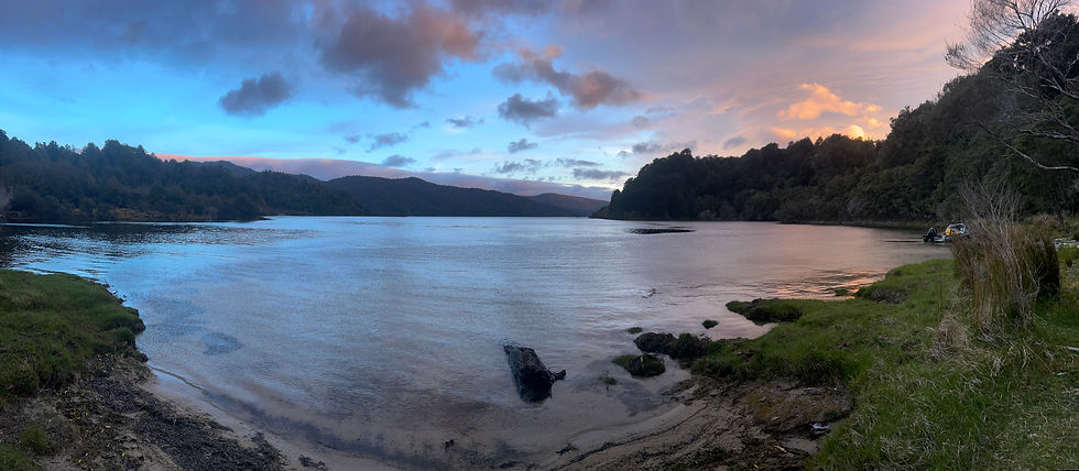
10. Lake Waikaremoana

This was the first proper hiking trail I did in New Zealand. The land is owned by the
Maori, and the huts are run by them too. It’s one of the few wooded areas in the North
Island that’s never been cut for logging, and it takes a long drive on unpaved roads to
get to it. The trail itself is a point to point trail along a lake, requiring a boat pickup at the end to return you to the start. The lake is pristine and also noted for its white caps
caused by so much wind.

The trail, even in the middle of the season, is one of the least popular trails, and arriving
in early October, it was mostly empty. The first day was certainly the best, with an
immediate big climb up a mountain. At the top, I walked along the shelf which abutted
the lake for a good while, providing great views from above. Eventually, I went back
down and ended the day at the lakeside.
The Maori warden of the hut told cultural legends, which I really enjoyed, and warned us not to accept alcohol from any boaters who might show up (none did). The rest of the trail was mostly flat, but on the second day did afford a side trail to a very pretty waterfall, Korokoro Falls.

That night, I saw two possums outside the hut. The third day was short, especially since the water taxi pickup point was before the actual end of the trail.
I am very glad that this was the first hiking-focused Great Walk that I did. It was beautiful, but most of the other trails on this list are either stunning or gorgeous.
9. Hump Ridge Trail

The Hump Ridge Trail is the newest addition to the Great Walks in New Zealand, having been added in October of 2024. In fact, even the trail’s creation is quite new, having been created in 2001. It is run not by the DOC, but by the nearby Tuatapere community. Its limited and separate affiliation caused me to book the Hump Ridge as a guided walk. This was my seventh Great Walk, and it came off the heels of doing three of my favorite Great Walks in New Zealand.
On the first day, we rode helicopters to the beginning of the trail, which would have been my first time in a helicopter had I not faced unforeseen circumstances a few weeks prior. It was still awesome, though, especially being able to sit in the front. The first day involved a climb up a mountain. I was immediately impressed by how much of the trail consisted of boardwalk. I could tell that this trail was new, and it was being very well taken care of. The views from the top of the mountain were very impressive, both for the large boulders, as well as the distance to which I could see (even Stewart Island’s outline was visible).

The second day involved going back down to the coast, going through some beautiful old forests, and also passing along the largest wooden viaduct in the Southern Hemisphere. The southern portion of this lollipop-shaped track used to be a big logging area, which is what caused the viaduct to be originally created. It also meant that the track was very smooth and even for the last few miles that day. On the third day, it rained quite hard, but after leaving the hut which was built near where the logging town used to be, I spent most of the path walking along pretty beaches.

The guided walk meant that the huts had hot showers and tasty cooked food, and I particularly enjoyed munching on a pleasant selection of macaroons at the end of each day. I think if I had done this one earlier, I would have appreciated it more. Nevertheless, I was still very happy to have done the hike, and there were certainly some great highlights of the trip. Additionally, the guides were quite good and the tour group size was very reasonable, at about 12 people.

8. Whanganui River Journey
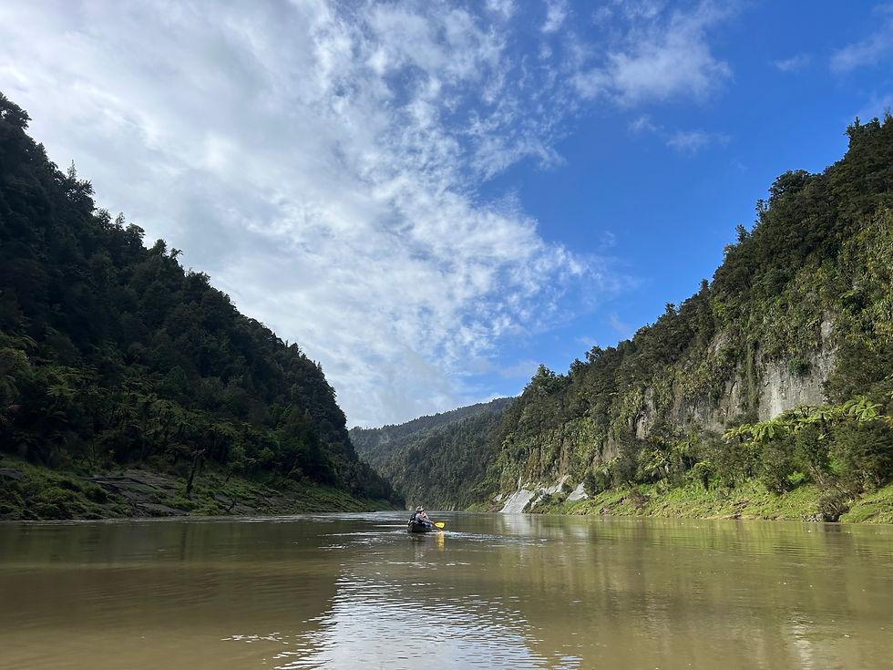
This was the first Great Walk I did, but this is actually a canoe trip rather than an actual hike. Because of that, I opted to do this North Island excursion with a tour group as well. Because I booked it for the first weekend in October, we were one of the first groups to be out on the Whanganui River for the season. There were only 4 people in my group as well, and since I was the youngest, as well as a solo traveler, I was given the option to kayak on my own, while the guide would canoe with the other solo traveler in our group.
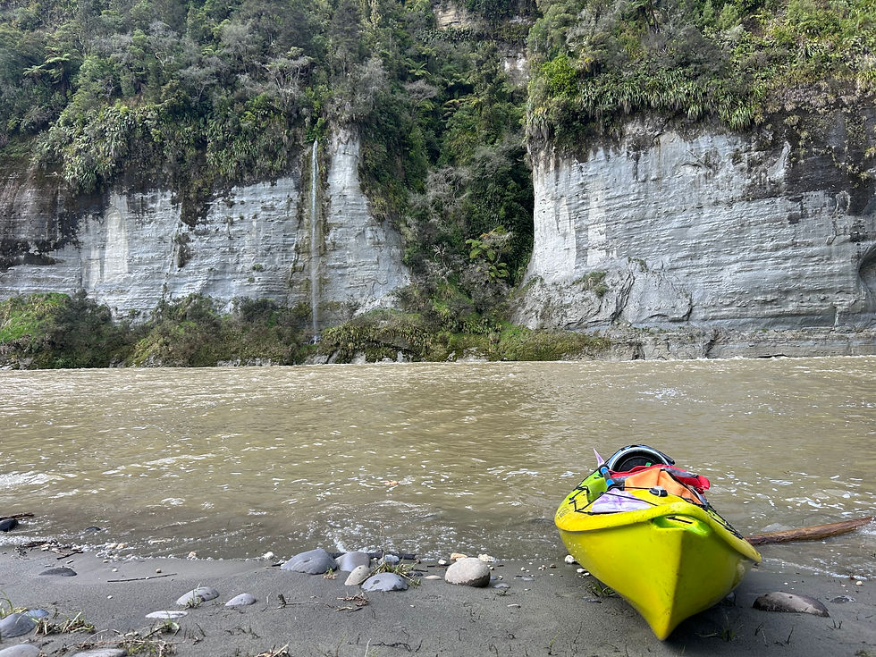
The journey was supposed to happen in 4 days, but due to rain, the water level was too high for us to leave on the day we originally planned. That said, because of the pace of the river, there was no issue in doing the same mileage in only 3 days. Over that time, I built a good connection with my other companions, especially a kiwi named Peter, who ended up hosting me for a couple days outside of Napier later that month. Despite all the rain leading up to the trip, we were actually rained on very little, and we were so early in the season that we came across no one for nearly the entire time. That, along with no other sign of human habitation, from a telephone pole to a road, made it feel very remote (the one exception being the Bridge to Nowhere, created back when the government tried and failed to turn this into a farming community in the early 20 th century). Other highlights include exploring the little slot canyons that feed into the river, as well as the waterfalls that dropped from the steep banks which line both sides of the river.
I enjoyed the variation of being on a river instead of a trail, and the uniqueness of the
trip, as well as the connections I made and the solitude it afforded, is what caused the
Whanganui to earn its placement.
7. Heaphy Track

I ended up starting the Heaphy Track on Christmas Day, making it my tenth Great Walk. This was one of the tougher hikes to plan logistically, because it is a point-to-point trail, meaning I had to plan for a shuttle to drop me off, and a separate shuttle company to pick me up. It starts in the mountains of Kahurangi National Park, the second-largest national park in New Zealand, and then makes its way to the western coast of the South Island. The grade of the trail is very smooth as well, because it’s one of two Great Walks to be traversable by bike (though it’s not allowed at the point in time I was hiking it). It’s also one of the few hikes where I spent more than 2 nights on the trail, but my first night was spent at the very start, so that I could hit the ground running the following day.

On the first proper day of hiking, I climbed up into the alpine region of Kahurangi. The hills here are not as high as other places in the South Island, so there are not rocky or icy tips to these mountains. That said, the ecosystems still manage to change quite a lot throughout the trail. While at first the views reminded me of the Appalachians, by the time I was done with my second day, I was viewing impressively large and interestingly shaped trees and walking beside large boulders. On the third day, it was a purely coastal track, with handsome palm trees and long beaches.

There is something for everyone on this hike, and despite its significant elevation gain, the grade is so smooth that my phone barely registered any of it. The wildlife along this trail is pretty good with chances to see giant snails and takahe (neither of which I personally saw here, alas). That said, a couple of the huts I stayed at were a bit older, and I have a soft spot for massive, imposing mountains, which this area simply does not offer.

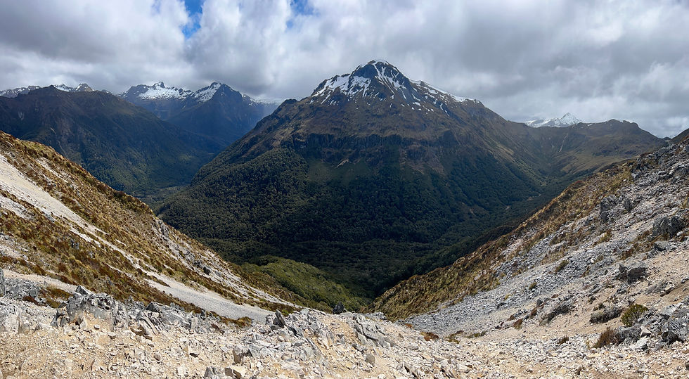
6. Paparoa Track

The Paparoa Track is the second-youngest Great Walk in New Zealand, having been inducted in 2019. It is aptly situated in the Paparoa National Park, on the west side of the South Island, opposite of Christchurch. It consists of a few older mining paths that were combined. In fact, one of the side trails includes the Pike29 trail. It is named after the 29 miners killed in a gas explosion in the Pike River Mine back in 2010. It’s the biggest mining disaster for the country since 1914, and the bodies have not been recovered due to the continued risk of explosion. Although that mine was focused on getting coal, gold mining is still a common thing in the area. Like the Heaphy, the Paparoa is a point-to-point trail that allows for both hikers and cyclists. This track also happened to be the final Great Walk that I completed.

The first day was a fairly straightforward uphill climb. The rain was falling lightly, and the sky was quite misty. The gradient was gentle, but still a bit too steep for the cyclists I met, who were walking their bikes up the mountain. Just a little past the tree line lay the Ces Clark hut, where I spent my first night. As the afternoon waned, the sky cleared at times to reveal some pleasant vistas.

The second day was about 18 miles, and the first half of it involved traveling along ridgelines. This was the best part of the trail, and the weather that morning held, making it a very enjoyable portion of the hike. At times in the distance, the west coast of the island could be seen. Eventually, I entered the Goblin Forest, beginning a slow descent back down. I still encountered several other ridgelines, but by then the weather had turned, and it was tough to see much beyond the trail. Every now and then, though, the clouds lifted a bit and revealed some cool sights.

The final day was a very wet one, raining almost the whole time. Between that, and being back in the woods, I did not get many expansive views, but eventually the trail came down to river level, and that afforded some decent sights.
I debated a good deal between whether to place this above or below the Heaphy Track. Although I loved the last part of the Heaphy, where I got to walk along the coastline, I was more impressed with the mountains and alpine views on the Paparoa. I also preferred the woodland portion of the Paparoa slightly. It was also not nearly as crowded as I expected the trail to be. I suspect the bad weather deterred a good number of people.

5. Abel Tasman Track

The Abel Tasman Track is one of the most popular of all the Great Walks. I think this is because it is, in comparison to a lot of the other tracks, very accessible. Several parts of the trail pass through campsites that people can drive to, and because the path is almost entirely coastal, there are tons of boats around. It’s the only Great Walk where I was able to find a little restaurant to eat a pizza at for dinner along the way. It’s an especially popular place in the summer. Interestingly, Abel Tasman National Park is in fact the smallest national park in the country, and the point to point trail runs from its north end to its south end. Despite that, figuring out logistics is significantly easier than it is for the neighboring Heaphy track.

My first day was relatively easy, climbing up the most mountainous part of the trail before returning to sea level. I took off my pack at the crowded hut and did a short hike on my own, enjoying the beautiful weather and pristine beaches. They were, on average, longer than the ones I saw in Rakiura, and the water was much more inviting. The area was not dubbed Golden Bay for nothing. The second day was very long, mostly because there was one section of the trail that is only traversable during low tide. Because of that, I had to sit for a couple hours with some weka, waiting for the tide to recede low enough for me to wade across to the opposite beach and continue my path.

Although this was a big delay in an already long day, it was my favorite part of the trail, because I never had to deal with something like that before (and the water and weather was pleasant enough to be waist-deep in the ocean). On the third day I crossed even more beaches, savoring the sun and enjoying the pretty views of the coastlines both near and far.

I can definitely understand why this trail is so popular. It’s a place that I would definitely
be willing to return to, but with less backpacking supplies and more beachgoing supplies. Even with the larger crowds, the beaches had more than enough room to not feel inundated with people.

4. Tongariro Circuit

The Tongariro Circuit is a walk around Mount Doom on the North Island. Although I did the circuit, it is possible to just do the crossing as a day hike, which is the main highlight of the whole trek.

Much of my hike was described in a prior post, so I will keep it brief here. Long story short, the track is almost all alpine, with parts that make it feel like you’re walking on the moon. The red crater, the mountain lakes, and the sulfurous smoke billowing out of the earth make this track incredibly unique.

I personally enjoyed the difficulty of this track. I also didn’t have to deal with crowds for most of the hike, due to the dangerous wind conditions. It was stunning and fascinating from beginning to end.

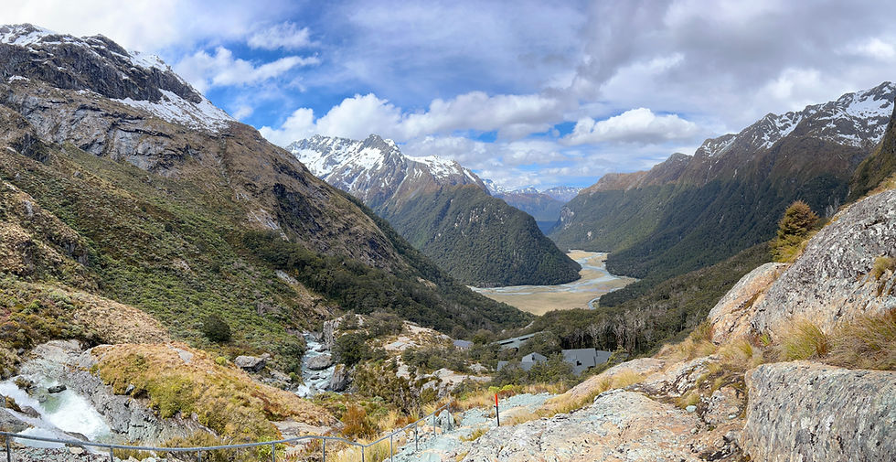
3. Routeburn Track

The Routeburn is a point to point trail in spanning both the Fjordland National Park as well as Mount Aspiring National Park in South Island. I did this trail with Ultimate Hikes at the very start of the hiking season there. The hiking group consisted of about 24 people, but the snowstorm which occurred a week prior prevented other hikers from being able to do the hike due to avalanche risk. As it was, my tour group had to take a short helicopter ride over a small section of the hike in order to continue along it. Because it was guided, it also meant I was lodged in nicer accommodations, with bedding, hot showers, and food provided.

The first day was misty, and so I spent much of the day walking along ridgelines, I was
unable to appreciate what would almost certainly have been phenomenal views. That
said, there were moments when I caught glimpses of it, and the woods that the trail went through were stunning of themselves. After the first day finished, I took a short walk along the nearby lake and enjoyed a phenomenal view all to myself.
On the second day, we climbed back up along the ridgeline and enjoyed unbeatable views for the entirety of the day. It certainly goes down as one of the most gorgeous days of hiking I’ve ever done, from beginning to end, with several stunning scenes of mountains and valleys. I also got to ride in the front seat of the helicopter when I got transferred over the area with avalanche risk.


Many people consider the Routeburn to be the best Great Walk. It is indeed exceptional. My only complaints are that it is shorter than I wish it was, and I did not get to enjoy some of the views that I probably could’ve had the weather been better that first day.
2. Milford Track

The Milford Track is known worldwide for a reason. Located in Fjordland National Park, the start of it is only accessible by boat, meaning you must first cross a gorgeous lake surrounded by mountains just to begin. The track ends at Milford Sound, considered the crown jewel of New Zealand in terms of stunning scenery. This hike was also guided by Ultimate Hikes, and I began it literally on the first day of the season, November 1.

The first day mostly involved just getting to and beginning the trail. That said, even the journey to begin the trail is beautiful, from the drive from Queenstown to the boat ride in. I was with a group of 50 people, which I thought was massive for a hiking group, but because the DOC wasn’t allowing anyone else on the trail because of a recent snowstorm, we were the only 50 people I saw for all 4 days of hiking. Therefore, it didn’t end up feeling so crowded. Because of the large group, we had 4 guides with us. The lodges were posh, and each of their locations were in very scenic spots. The first day was clear blue skies, a true rarity for that area. And with the snow-capped mountains all around, even the guides were taking photos of area.

On the second day, the hike began in earnest, walking along a valley. It was carved by glaciers, which is what causes the mountainsides to be so sheer. Waterfalls abounded, and it felt fantastical.

The third day welcomed another unusually clear and bright day, but unfortunately, we had to take a helicopter over the iconic MacKinnon Pass due to avalanche risk. It was heartbreaking, but at the same time, this was my first helicopter ride ever, and I got to sit in the front and enjoy some of the best views of my life. (Ironically, out of 54 total people, the helicopter which only seats 6 at a time had to go not 9, but 10 times back and forth over the pass to get everyone across. I was the only hiker on the 10th and final ride.) After that, I hiked down the rest of the way into a different valley and took an hourlong detour to visit the tallest waterfall in New Zealand, Sutherland Falls.

The fourth day was misty again, yet the views still amazed, and the forests were as lush as anything I’ve ever seen. We ended at Milford Sound, which was shrouded in mist, and dined on New Zealand lamb to celebrate our time together.
On the fifth day, we took a boat ride on the Milford Sound. Just as the tour began to end, the fog finally lifted, and I got to see just how beautiful the sound can be. Among the guests were 6 people over 70 years old. It was incredible to see them doing this hike, and 4 of them accompanied me on the Routeburn as well. I was also joined on both routes by an Australian, Matt, who I often shared a room with. We shared some beers in Te Anau and he taught me cricket as we waited to be picked up the next day to begin the other Great Walk.

Between the superlative views and the delight of being taken care of by a quality hiking company, it is tough to say anything is better than this. Food, lodging, companionship, and all the rest were better than imaginable. I remember joking after dinner that dessert would be crème brulee – then lo and behold! – crème brulee appeared. I even saw my first kea as we were leaving Milford Sound.

1. Kepler Track
The Kepler Track takes the top prize for me. Like the others in the top 3, this one is also in Fjordland National Park. It is a loop trail, not far outside of the town of Te Anau. I completed this one on my own, soon after the avalanche risk had finally subsided, but I also returned here for a short hike with my parents when they visited. Both times, the weather was very agreeable, which helped a lot.

My first day on the trail was particularly long. I began early in the morning, walking along the edge of Lake Te Anau, the largest lake in the South Island and the second-largest lake in the country. (It’s the same one must cross to begin the Milford track.) After a few pleasant miles, the track climbs up a mountain at a reasonable gradient. Once above the tree line, the view opened up and I could catch a glimpse of Te Anau, nestled between lake and mountains. I soon arrived at Luxmore hut, where I had my interaction with kea and lost my dehydrated pineapple (see the blog post about the birds of New Zealand for the full story).
After a short visit to a cave, I continued on, climbing even further until I reached the peak of Mount Luxmore. After that, I walked along the ridgeline, enjoying panoramic views for miles. Kea followed me, making the walk even more pleasant. Finally, I took a steep path down into the Iris Burn valley, and there spent the night.

Although I was staying at DOC huts, and not doing this with any guided group, the amenities were quite nice. Not only were there the typical bunks, mattresses, faucets, and fireplace, but there were also gas stoves for cooking and even flushing toilets.
The next morning, I woke up and took a short walk to Iris Burn Falls, eating my breakfast of granola bars alone rather than in the hectic hut. Hiking down in the valley, I enjoyed a slightly less spectacular version of the Milford track, still managing to see some waterfalls cascading down the steep mountainsides. The day ended at another large and beautiful lake, which I took the afternoon to walk around some of.

On the final morning, I woke up particularly early, before anyone else, and I set off, getting to see the sun begin to color the sky as I admired the wetland portion of the hike. I then walked alongside a river which The Lord of the Rings filmed a scene at.

I placed this hike as my favorite for a few reasons. Firstly, the kea experience was particularly special to me, and this is one of the only Great Walks where I got to enjoy them and learn just how cheeky they can really be. The weather afforded me great views, and the difficulty of the track, as well as the fact that I was doing this one unguided, made it personally more rewarding than either the Milford or the Routeburn.


Comments