


The National Parks of Utah
Updated: Aug 3

I’ve been mesmerized by Utah since I first went there in the summer of 2009 with my Boy Scout troop. Since then, I’ve returned two more times: once in 2021, and again this year. It takes a lot to get me to return to a place I’ve already traveled to, and to return a third time puts it in a very select group of places. Yet this state has some of the most incredible rock features I’ve yet to see finer examples of.

Utah is outnumbered in national parks only by California and Alaska, and all five are grandiose and unique. Funnily enough, they are all in southern Utah and no further than two and a half hours from one another, making them ideal for road tripping. Even beyond that, the state parks and other outdoor sights across southern Utah and northern Arizona are exquisite, like Goblin Valley and Dead Horse Point State Parks. I drove by many places and thought to myself, “Heck, why not this, too? That looks worthy of national park status at least as much as Cuyahoga!”

To commemorate the state, I will describe the five National Parks of Utah:
Zion National Park
147,242.66 acres (595.9 km2) | 4,984,525 visitors (2nd place)

Nothing beats that first sudden blast of scenery going through the Zion-Mt. Carmel tunnel for the first time westward into the park. It takes one’s breath away. There’s a reason the movie Butch Cassidy and the Sundance Kid filmed partially here in Zion and won an Oscar for best cinematography. (As a side note, Butch Cassidy’s childhood home is in southern Utah and can also be visited.)

Zion is the only place in Utah I visited all three times. It is undeniably the most scenic, with iconic features such as its entrance, Angel’s Landing, and the Narrows. That also means it’s one of the busiest national parks in the entire country. In order to get into the main area of the park, you must use a shuttle. I remember waking up to arrive at 5:45 am, 15 minutes prior to the first shuttle departing, only to still be over three busloads behind.

The first time I visited, we had a local who knew these parks, so we did something totally different that almost no one does: a trail called Fat Man’s Misery and another one through a half-filled slot canyon. Those were epic days.

The second time I went, I visited the more touristy things, such as Angel’s Landing, the Narrows, and the Emerald Pools. It helped tremendously to arrive early, but by early afternoon, everywhere was heavily trafficked.
This last time, having done all of that, I was more passing through. I did stop to walk along the valley on the paved greenway called the Pa’rus Trail and dipped my toes in the comfortable waters of the Virgin River. Even that was totally delightful, and I still saw a couple of deer.

Because of the tourism industry around Zion, there is also plenty of lodging and restaurants around. The food is good, but prices are higher.

Arches National Park
76,678.98 acres (310.3 km2) | 1,511,740 visitors

Unfortunately, my most vivid memory of this place is that Michael Jackson died on the day I visited Delicate Arch. That said, upon my revisit, I had the chance to see a lot more of the park than I did the first time.
Surprise: this park has a lot of arches. It certainly doesn’t hold all of them (I’ve seen arches, bridges, and windows in Canyonlands, Capitol Reef, and Bryce Canyon), but Arches holds a dense number of them, and they are some of the finest examples.
Arches has the benefit and drawback of being a 15 minute drive from Moab. Lodgings and food options are abundant, but that (along with its iconic views) also results in higher tourism rates. Many of its best features are short hikes, which make it accessible to a lot of people.

While I only recall seeing Delicate Arch on my first visit, I made sure to take the time to explore a few of the other areas on this most recent road trip, like the Devil’s Garden area and the Windows.

Capitol Reef National Park
241,904.50 acres (979.0 km2) | 1,388,476 visitors

My first time to Capitol Reef was on this most recent road trip. This national park has a significant amount of sites that are only accessible via unpaved roads that require 4 wheel drive, so I rented a Jeep for the express purpose of seeing more of this park. Due to time constraints and how the road trip played out, although I went on some of the roads that led to areas of the park, I did not drive into the national park itself on one of these rough roads. However, even the sights surrounding the national park are rather special. Factory Butte and the Bentonite Hills are fine examples.

The main section of the park itself was a fascinating amalgamation of different features I’ve seen elsewhere in Utah. For example, it has a trail called the Narrows like Zion does, but it is not an active riverbed. It’s still very neat, though. Likewise, it had a view into a smaller canyon carved by time to become goosenecks, similar (though admittedly slightly less grandiose) to Goosenecks State Park, also located in southern Utah.
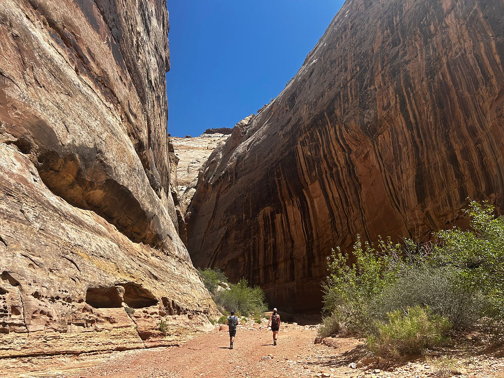
You get to drive right alongside a massive monocline as you enter Fruita, which boasts a history that includes both Mormon buildings and Navajo petroglyphs. It also has a natural arch (Cassidy Arch) and a natural bridge (Hickman Bridge), all easily accessible.

Fruita, itself, and the surrounding areas are quite small, but there are lodging and food options within 20 minutes of the park; however it’s one of the tougher places to find a lot of choices.

Bryce Canyon National Park
35,835.08 acres (145.0 km2) (13th smallest) | 1,967,367 visitors

Bryce Canyon has some of the most photogenic trails I’ve ever done, thanks to its captivating amphitheater of spires and hoodoos. It reminds me of giant versions of the wet-sandcastles I used to build with my brother on the beach growing up. Despite their small size, the paths offer twists and turns that surprise and delight.

I first came here in 2021 and did two days of hiking, doing the famed Figure 8 Loop the first day and the Fairyland Loop Trail the following day. I remember the horse poop being very smelly in the summer heat, especially along the popular Peek-A-Boo loop (part of the larger Figure 8). Ironically, this time I chose to do the horseback riding experience. It was very pleasant, and the weather was somehow not so unbearably hot.


Surprisingly, the lodgings around Bryce Canyon, as well as its restaurants, are a bit more scarce. That said, if you are not going to hike, the sightseeing can be done in a day, and it is not terribly far from either Zion or Capitol Reef, both being around two hours distant. There are a handful of great viewpoints, as well as a natural bridge, but the joy of this place is going down into the amphitheater.

Canyonlands National Park
337,597.83 acres (1,366.2 km2) (24th largest) | 796,057 visitors (35th least visited)

Canyonlands is the largest national park in Utah, and it is really separated into three main regions: Island in the Sky, The Needles, and The Maze.

Most visitors end up in Island in the Sky. It is basically a plateau that you can drive atop of, and you then get exquisite views of canyons from every direction. Hidden within the deep grooves that blanket the park below, the Green River meets with the Colorado River. There are a few small hikes and several viewpoints, making it the most accessible part of the park, though it’s still over an hour from Moab. It has iconic views, and you can see the other portions of the park from Island in the Sky, though canyons lie between.

The second area, the Needles, is great for hiking and exploring. There are still interesting rock formations beyond the stone teepees that The Needles gets its name from: mushroom-like stones and arches can be found here too. It’s also an hour and a half from Moab, but it a completely different direction than Island in the Sky. Despite its relative proximity to Moab, the trails are not nearly as crowded as one might think, and the drive in is quite extraordinary as well.

The Maze is more for people who are very skilled in outdoor survival and navigation since it is very easy to get lost in. I have not visited this portion of the park, but there are supposed to be interesting things in that section, including some impressive petroglyphs.

I particularly enjoyed visiting Canyonlands during this most recent road trip. I think there is something for everyone with this national park, and its size allows for plenty to explore.


I didn't get to spend much time in Utah when I traveled there as a 15-yeqr-old with my parents & 20-year-old brother, Ray, but I liked Bryce Canyoun the best. I remember learning then that a local rancher called it "a helluva place to lose a cow".